Photo by Steve Resotko
Steve Resotko drew this map of Pleasant Bay Island. Looking closely you can see Big Nash Island in the right bottom corner. The jaw bone and vertebrate hold down the map was an attempt to play pirate for a nanosecond-then back to reality.
Photo by Joe Palmer
Big Nash Island is the sister island to little Nash where the light house is located.
After landing on Big Nash I took this storm pool photograph.
Photo by Joe Palmer
The northwest side of Big Nash Island slopes up to 30 to 40 feet in height with a series of sand dunes. One can find interesting things which have been washed ashore. This picture shows part of what may have been part of an old pier.
At this point were walking on the top sand dune of the northwest side of Big Nash Island.
Flower Photos by Joe Palmer
We saw piles of drift wood scatterer here and there along this side of the island.
Nestled into the empty place of the log and branches was this clump of beautiful Maine wild flowers.
How did these flowers get here.
Maybe a bird dropped seeds here on its migration route.
Steve reminded me that one of the reasons we landed on the Northwest side of the Island was to find Clifford Purington's grave stone.
Steve reminded me that one of the reasons we landed on the Northwest side of the Island was to find Clifford Purington's grave stone.
We began looking for his grave marker. Its location was not far from the patches of flower. More or less we stumbled upon his marker by accident. Who was Clifford M. Purington? Why is Jennies grave next to his? My guess is that Clifford and John
were brothers.
To our surprise we saw another grave stone next to Clifford Purington's
Jenny was married to Stanley Cirone of South Addison when she was not quite 21. Keeper Purington retired because of poor health in 1935. Jenny Purington Cirone eventually purchased the non-government-owned land on Nash Island as well as all of Big Nash Island.
Steve Resotko photographs the grave stones
Photo by Steve ResotkoSteve also captured this picture of the graves with Little Nash Light House in the distant background.The tide was beginning to change and we need to go to the East end of the Island.
We put ashore. Steve anchors his boat.
Walking to higher ground we see a large wooden pen.
Walking to higher ground we see a large wooden pen.
Photo by Steve Resotko
The pen is situated a good distance above high water mark with a larger entrance to accommodate sheep would be my guess.
Photo by Joe Palmer
Looking left and right of the sheep pen, one can see two post with fenced rolled up and tied to the post. These posts and pen are further evidence that sheep were located on this island at some point.
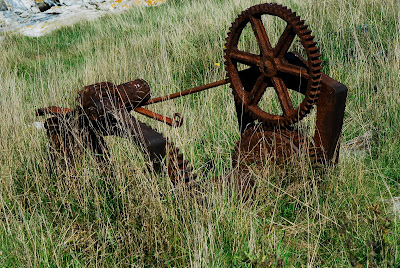
A large boat winch has been retired to a field of weeds on Big Nash Island.
Photo by Steve Resotko
Steve snapped this picture of of a nice looking house facing East.
Photo by Steve Resotko
Beside the house was a white enamel sink with a ole fashion hand pump left and behind the post.
Photo by Joe Palmer
In front of the house sat a picnic table with a small fire pit made of beach stone near it.
Photo by Joe Palmer
A porch stretched the length of the house's front. Seen here is a decorative post wrapped with rope.
Photo by Joe Palmer
At the base of the post was this ole wooden weather beaten lobster buoy.
Photo by Joe Palmer
The side of the house had a functional and beautiful four pain window.
Steve and I concluded our exploration of the East side of Big Nash Island.
We would be heading back with the incoming tide to the town pier in Milbridge, Maine.

Picture was taken on the eastern end of Big Nash Island.
We wave from our hearts farewell to this scenic windswept Island.


No comments:
Post a Comment